One of the items still on my scenProc wishlist is adding a feature that allows you to vary the heights of the autogen buildings In the current version you have to set the same height distribution for all autogen tiles. But how to do that? I started a thread on the forum a while ago to discuss the possibilities and at the moment I see a couple of ways this can be done.
- First option is to let the user draw some polygons manually where he wants more hi-rise buildings. All areas not covered by these polygons would get the low buildings only. Since KML file can now be read, these polygons could even be drawn in Google Earth quickly.
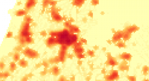
 A second option is to find and use some vector data that contains information about population density, amount of houses in an area or something similar. For the Netherlands I found some (free) data from the national statistics bureau that gives information about amount of people, population density and even amount of houses for the entire country. This information is given for cells of 500×500 meter. To the right is a screenshot of this data.
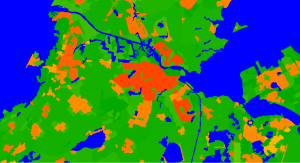
 A third option would be to use a raster image with population density data. I did not yet find a good source for this however. I found some population density data at the EEA website that covers most of Europe. But it only showed the population density per municipality. Which means that the city centre and the suburbs have the same density. While the aim is to vary the autogen between those parts of town of course. I have included a screenshot of this data on the right again. But there might be better data available and then using raster data would be a good idea.
So with those 3 ideas in mind, how am I going to implement it in scenProc? In the end it all comes down to the same idea. Taking the centre coordinate of the autogen tile the available data should be checked for the population density and than based on the value a selection is made for the distribution of the buildings heights in the autogen. So let’s see if I can get that coded…
 SceneryDesign.org